GMDA Version 1.3 Release Notes
Windows 8+ users, click HERE to download v1.3 (zip).
Auto-update no longer works on Windows 8+.
This release contains bug fixes. It is recommended you update to this version.
Changes for Version 1.3:
Bug Fix:
Resolved Issue: Crashes and inaccurate calculations on non-US systems employing comma-based decimal systems.
GMDA Version 1.2 Release Notes
This release contains important updates. It is highly recommended you update to this version.
Changes for Version 1.2:
1) New Measures: Scaling bias and Rotational bias
Description:
Scaling bias measures the direction of scaling of inter-landmark distances on the sketch map.
Positive values indicate over-scaling of inter-landmark distances on the sketch map and negative values indicate under-scaling.
Rotational bias measures the direction of angular error of inter-landmarks angles on the sketch map.
Positive values indicate clockwise rotation of inter-landmark angles on the sketch map and negative values indicate counter-clockwise rotation.
2) Individual Landmark Measures!
Description:
GMDA now calculates GMDA-unique and BDR measures for individual landmarks.
GMDA-unique measures (Canonical Accuracy, Scaling Bias, Rotational Bias, Distance Accuracy, & Angle Accuracy)
are calculated for every drawn landmark in the sketch map.
These measures allow for landmark-level analyses and allow for comparison
of the accuracy of individual landmark placement. They can be calculated in basic or advanced mode.
BDR individual landmark measures can only be calculated in advanced mode. Not all are interpretable.
r reveals shape distortion
scale reveals size expansion/contraction
alpha 1,2 reveal translation
3) Data output is now split into two files
Description:
a) a Raw file containing a log of the conducted pairwise comparisons and the coordinates used in bidimensional regression
b) a Summary file containing the calculated measures
4) Inter-landmarks Distances have been added to the raw files.
Description:
These are raw distances not distance ratios (which are still included in the raw files).
5) Distance Accuracy bug fixed
Description:
Distance Accuracy relies on the calculation of distance ratios. The denominators of these ratios is the maximum inter-landmark in the target environment
and the corresponding distance in the sketch map.
We corrected a bug where the maximum distance calculated in the target environment
included landmarks that were missing from the sketch map. Now only landmarks that were drawn in the map are used to calculate the max distance.
If you have been using distance accuracy in your research we strongly recommend reanalysis of your maps. GMDA's batch analysis function makes
this easy.
Bug Fixes:
fixed bug where loading consecutive configuration files for rotated maps leads to innacurate rotation. This bug did not affect batch reanalysis.
fixed programming bug when actual map set as IV in bidimensional regression (indices overflow issue)
fixed bug in advanced mode. When missing landmark was marked "non-missing" the box color was not changed back to the selected color on the palette
fixed bug in advance mode. When missing landmark was marked "non-missing" a subsequent mouse click anywhere on the map would move the landmark.
total correct field has been removed from summary output
GMDA Version 1.1 Release Notes
This release contain important updates. It is highly recommended you update to this version.
Changes for Version 1.1:
1) New Measure: SQRT(Canonical Organization)
Description: Canonical Organization is limited because it follows a quadratic function.
As the number of missing landmarks increases, the Canonical Organization score decreases at a quadratic rate.
This function is the following:

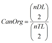
In version 1.1 we now include in the data output SQRT(Canonical Organization). This measure is the square root of the Canonical Organization score.
This measure linearly transforms Canonical Organization's quadratic function. As such, SQRT(Canonical Organization) is more suitable for maps that have many missing landmarks.
2) Bug fixes to batch reanalysis
Description: We corrected a bug that specifically affected batch reanalysis in advanced mode.
During batch reanalysis landmarks appeared as if they were missing when they were not.
This was an aesthetic bug and did not affect the accuracy of the data analysis.
We've corrected this and added a progress bar to the batch analysis process.
GMDA Version 1.0 Release Notes
This is the alpha version of the GMDA software. Be sure to install future updates when they are available.